
Hidden Google Map Tricks You Never Knew About
Get the scoop on parking
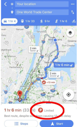
Even after you get to your destination, parking can still be a major obstacle. Fortunately, Google Maps can tell you what to expect. Enter your destination and click the car icon for driving directions. In many cities, you’ll see a ‘P’ icon at the bottom of the map. That stands for parking. Next to the P, you’ll see limited, medium, and easy. These designations can help you plan our how far ahead you’d like to leave. Got a parking ticket?
Remember where you parked
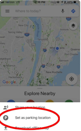
Now that you’ve found a place to park, you might want a helping hand in remembering where that precious spot is. Android users can tap the blue dot and then tap “Save your parking” to add your parking location to the map. There will be a label on the map showing where you parked your car. Tap on that label to open up your parking card, where you can add relevant details and even schedule a reminder alert 15 minutes before your meter expires. The Apple iOS experience is similar. Tap on the blue dot and then tap on “Set as parking location” to add your parking spot before the tapping on the parking label on the map to open up your parking card.
Find anything, anywhere
You probably already know that you can type “coffee shop near me” into Google Maps to get a list of coffee shops in your area. But did you know you can search destinations even if you’re a thousand miles away? For example, search “cozy restaurants near the Bronx Zoo,” or “beer halls near the White House.” Give it a try. Just remember, with Google’s “My Activity” you (or anyone with access to your Google account) can view all of your online activity unless you tap on your user name icon in the right corner and turn in incognito mode in the drop-down menu.
Find a safe bike path
Biking in an unfamiliar place can be intimidating—especially when you don’t know what types of paths to expect. Google Maps has got your back. Enter your destination in the search box, tap on “directions” and then hit the transit tab. From there, you’ll see routes that feature cycling options plus directions. For more detail, click “destinations” in the Go icon, enter your destination and click the biking icon on the top of the screen. Along with your route, you can also get some intel on the terrain.
Share your location
Heading out on a weekend trip and want to make sure your otherwise anxious mom can follow along? Google Maps now allows you to share your location. You can even customize the length of time this info is available so she doesn’t snoop too hard. Tap on the location-sharing button in the upper right corner and then follow the prompts to “select people.” From here you can share your live location, route, and ETA with any or all your contacts.
Price shop for ride shares
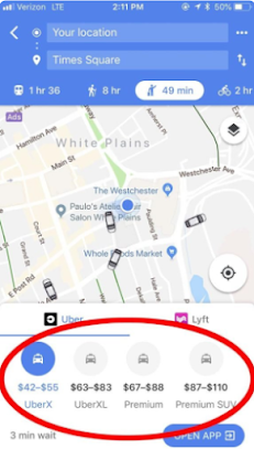
Everyone knows how annoying it is to type your destination into each of your ridesharing apps to see which is cheapest. Fortunately, Google Maps can help you view all the options in one place. Simply type in your destination and tap the icon of the person hailing a cab. Google Maps will show you each ridesharing service in the area, as well as the cost of each travel option (for example, with Uber you’ll see UberPool, UberX, UberXL, etc.). You’ll still have to go to the ridesharing service’s app to request your ride.
Post a Comment
Please do not enter any SPAM link in comment box.